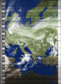
Immagini dal satellite meteorologico
Ricevuto da IV3ONZ - Redipuglia (Go), JN65RU, 14 m slm.
|
Latitudine: 45°50.64'N, Longitudine: 13°29.36'E Software: WXtoImg version 2.10.11 Ricevitore: NE LX1375 + pre TeleSystem Antenna: QFH autocostruita |
 |
|
Powered by WXtoImg |
(C) Image by NOAA Department of Commerce |

Informazioni sui satelliti
APT STATUS REPORT 26 11 2023 (Osservazioni presso il mio QTH):
| Satellite | Frequenza | Stato | Qualitá |
|---|---|---|---|
| NOAA-15 | 137.62 MHz | ON AM Secondary | BUONA |
| NOAA-18 | 137.9125 MHz | ON PM Secondary | BUONA |
| NOAA-19 | 137.1 MHz | ON PM Primary | BUONA |
Il segnale ricevuto suona cosí ...
Note:
- Update #21: At 17:11:00 UTC on November 02, 2023, the operations for all the three legacy NOAA satellites, NOAA-15, NOAA-18 and NOAA-19, have transitioned into the POES Extended Life Ground System of which operates the POES Constellation in a best effort data of opportunity manner, with no data product quality or data delivery latency requirements. Their images have been initially reviewed by NESDIS and appear valid, however data quality assessments remain ongoing. All distributed data may be used at the user's discretion. On top of NOAA-15 and NOAA-18 data distributions, PDA data distribution for NOAA-19 is scheduled to begin on November 02, 2023 at 17:11:00 UTC.
- Note: Since October 9th, the NOAA-15 AVHRR Scan Drive Motor is now operating in a degraded manner and all AVHRR Products could incur scan line outages.
- Note: Direct readout data from NOAA-15, NOAA-18 and NOAA-19 will continue to be made available to those users of that service.
- NOAA-15: As of 0000 UTC July 30, 2019 (DOY 211), the AVHRR motor current has once again started spiking, becoming saturated above 302mA at 0600 UTC. The instrument is once again no longer producing data and may be stalled. The current plan is to leave the instrument powered as this issue may be intermittent.
Queste informazioni sono ricavate dal sito web del NOAA NOAA Office of satellite and product operation - POES Operational Status
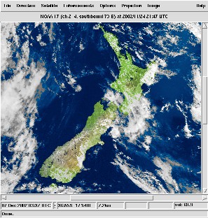
Ultima immagine ricevuta dal satellite NOAA 17 il 27 settembre 2010, alle 18.50 UTC (MCIR enhancement):